

Description
This short walk takes you on a route round the historic village of Midhopestones, presents two unusual troughs and an ancient sacred well as well as an easy walk alongside Underbank reservoir.
Information
- Length – 1.1 miles
- Grade – Well marked paths, some stiles, steady ascents. Parts can be muddy and slippy
- Start – Mortimer Road by ‘Ye Olde Mustard Pot’. Park on roadside.
- Grid Reference – SK 238 996
- Maps – OL1 Dark Peak
- Parking – Park on roadside
- Public transport – Buses (service 26 and 26a Barnsley) stop at the crossroads on Manchester Road.
- Public Toilets – none on the route
Download the route information and gpx data.
Bradfield Walkers are Welcome routes can be found as recommended routes on the OS Maps App for mobile phones , tablets and pc.
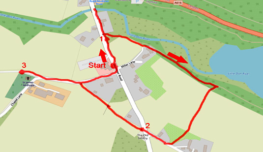
Map of the route
Mobile Phone Coverage – Mobile phone signal coverage is mostly good in this area. Intermittent signals can be received on higher ground.
Ordnance Survey map OL1 Dark Peak is recommended for all the routes on this web site.
Great care has been taken to ensure that the information on this web site and associated documents is accurate. However, we accept no liability for any claim, loss, damage or injury (howsoever arising) incurred by those using the information provided. Except where expressly stated to the contrary, copyright in the text, graphics and information contained in this web site (including downloads) is owned by Bradfield and Stocksbridge Walkers. You may print, or download to a personal computer, extracts for personal use. Permanent copying and/or storage of whole or part of this web site or the information contained therein or reproduction or incorporation of any part of it in any other work or publication whether paper or electronic media or any other form is expressly prohibited unless agreed otherwise.
Copyright – Bradfield and Stocksbridge Walkers 2024